Nearby toilets at a glance
See nearby options immediately instead of walking around blindly.
Use this Paris public bathroom map when you need a toilet near me, bathroom near me now, restroom near me, a WC open now, or the shortest safe walking-distance route from a landmark, metro stop or train station. Find the nearest open toilet by walking distance before you download or start walking.
Walking-distance promise: cacaou helps you compare the closest toilet, bathroom, restroom or WC options first so you can choose the fastest realistic route instead of guessing block by block.
Use the Paris toilet map for an open now check, free vs paid context, and tourist-area routing before you leave the Eiffel Tower queue, Louvre entrance, Notre-Dame area or Gare du Nord platform.
Purple toilet markers appear on the Paris map so you can compare nearby options, walking direction and other useful city points while you are already outside.
Need a bathroom open now? Download the app, allow location, and use the purple toilet markers to choose a nearby WC before you leave the queue, platform or café.
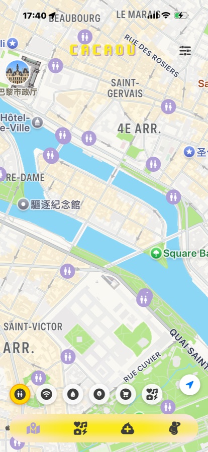
cacaou toilet map: example public toilet markers in central Paris
Because toilets are one of the most urgent city needs. cacaou puts nearest public toilet options, walking distance, opening info, accessibility and route guidance into one fast decision flow instead of making you guess street by street.
Use it for searches like “toilet near me”, “toilets near me open now”, “nearest public bathroom map” and “restrooms near me walking distance” while you are already moving through Paris.
For landmark and station trips, compare options near the Eiffel Tower, Louvre, Gare du Nord and Notre-Dame before leaving the queue, platform or metro exit.
Once that urgent problem is solved, stay in the same app for the Paris free WiFi map, drinking water and nearby activities.
Tourists, commuters, parents, people between train connections, museum visitors, or anyone who suddenly needs a reliable toilet option in Paris without wasting time.
Not just locations, but better decisions
See nearby options immediately instead of walking around blindly.
Use accessibility info to choose the most suitable location.
Jump from discovery to route guidance in a single flow.
Use the map first, then choose the safest and fastest option for your route.
When the need is urgent, prioritize toilets that are closest to your current route and have recent opening or availability signals. Public city toilets can be affected by cleaning cycles, maintenance or events, so always check the latest map details and the signs on site.
A toilet that is 300 metres away across a busy boulevard can be slower than one 450 metres away on your side of the street. Use cacaou to compare route direction, nearby crossings and whether the option fits your next stop.
Paris has many free public toilets, but toilets inside train stations, department stores, cafés or museums may be paid, ticketed or customer-only. cacaou helps you compare public options first, then decide whether a nearby private venue is worth it.
If you need wheelchair access, extra space, a stroller-friendly route or a calmer location, do not choose only by distance. Compare accessibility notes, approach route and nearby streets before you start walking.
Late in the evening, prefer options near lit avenues, busy metro exits, restaurants or open cultural venues. Keep a backup toilet on the map so you do not have to wander down quiet side streets.
Around Gare du Nord, Gare de Lyon, the Louvre, Notre-Dame and the Eiffel Tower, queues and access rules can change quickly. Check two or three options before leaving a station, museum line or sightseeing route.
Sometimes near the station, rarely something to rely on inside every metro stop.
Paris metro stations do not all have public toilets inside the paid area. Large train hubs and interchange areas such as Gare du Nord, Gare de Lyon, Châtelet-Les Halles or Saint-Lazare are more likely to have toilets nearby, but access, payment and opening hours can change.
If you search “are there toilets in Paris metro stations”, use cacaou as the backup: open the nearest public toilet open now, compare walking time from your metro exit, and keep a street-level alternative before you enter or leave the station.
Different search words point to the same urgent Paris need.
If you are visiting from the United States, “bathroom near me” or “restroom near me open now” often means a public toilet you can reach quickly. In Paris, signs and local listings usually say WC, toilettes or toilettes publiques. This page uses all of those terms so you can match the wording you search with the wording you will see on the street.
For the fastest result, search less by the exact word and more by the situation: nearest public toilet, open now, accessible, free or paid, and walking distance from your current route.
Useful search patterns for tourists, museum visitors and station transfers.
Around the Eiffel Tower and Champ de Mars, crowds and queues can change quickly. Check several nearby options before leaving the main route.
The Louvre, Tuileries and Rue de Rivoli area involves long walking distances. Compare route time, not just straight-line distance.
For train changes, choose the simplest walking route and keep a backup option around the station or main streets.
On Île de la Cité, options can be split between the riverbanks, Latin Quarter and nearby bridges. Open the map before crossing the river.
The Marais has narrow streets and busy shopping areas. Navigation details are often more useful than raw distance.
During events or shopping peaks, keep more than one option ready and prefer well-lit main avenues at night.
3 quick ways to save time
Many city-managed toilets are free, while some toilets in stations, shops or museums may be paid or restricted.
Open cacaou, compare the closest public toilet or WC options, then choose a route using opening and accessibility clues rather than distance alone.
Yes. Those American search terms usually map to public toilet, WC or toilettes publiques in Paris, so use cacaou to compare the nearest public options.
Not in every metro station. Large hubs often have toilets nearby, but rules vary; check the map for a station-side or street-level alternative.
American visitors often search “bathroom near me” or “restroom near me”. In Paris, the most reliable wording is usually public toilet, WC or toilettes publiques.
Use the landmark guidance above for Eiffel Tower, Louvre, Notre-Dame, Gare du Nord, Marais and Champs-Élysées.
Some are accessible. Check accessibility notes and the walking route before you choose.
Prefer well-lit places near main streets and keep a backup option on the map.
Keep the Paris toilet map in your pocket